Tropical storm warning issued in Louisiana for major flood threat
Tropical Storm Warning Issued in Louisiana for Major Flood Threat
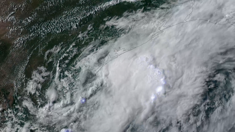
Tropical storm warning issued in Louisiana – A tropical storm warning has been issued for sections of Louisiana’s coastline, signaling the potential for a system to evolve into a short-lived tropical storm. The National Hurricane Center (NHC) is monitoring the development closely, with the system currently located approximately 15 miles south-southeast of Corpus Christi, Texas, as of 7 p.m. CT. While not yet officially classified, it has been labeled Potential Tropical Cyclone One, a designation used for systems that may soon bring tropical storm conditions to land within 72 hours. This label underscores the risk, as the system is expected to transition into Tropical Storm Arthur by early Wednesday morning as it moves into the northwest Gulf of Mexico.
The broader implications of this weather system are already evident. From Tuesday to Thursday, the NHC has highlighted a Level 3 threat out of 4 for flash flooding across Texas, Louisiana, Mississippi, and Alabama. This rating reflects the severe risk posed by heavy rainfall, with some areas anticipating 3 to 4 inches of rain per hour. In extreme cases, up to 12 inches of precipitation could fall in parts of southern Louisiana to central Mississippi and western Florida. The flooding has already disrupted communities, with reports of overwhelmed drainage systems and impassable roads in multiple locations.
As the system progresses, it is forecast to shift inland over east Texas or southwest Louisiana by late Wednesday or early Thursday. This movement could exacerbate the flooding, particularly in regions where prolonged rainfall has saturated the ground. Officials have issued flood watches for more than 27 million people spanning from South Texas to central and southern Mississippi. Cities such as Brownsville and Houston in Texas, Lake Charles in Louisiana, Jackson in Mississippi, and Atlanta in Georgia are among those facing the highest risk of flash floods. The intensity of the downpours has led to significant challenges, including the need for swift water rescue operations in several areas.
Impact of Heavy Rainfall
The system’s moisture, combined with a stalled weather front, has already triggered widespread flooding. Since Sunday afternoon, over 120 reports of flood-related incidents have been logged in Texas, Louisiana, and southern Mississippi. The most severe case occurred in Bandera County, northwest of San Antonio, where a woman was tragically swept away by floodwaters on Monday. She had called 911, describing her vehicle as being “floating downstream at a high rate of speed and unable to exit her vehicle.” Authorities lost contact with her before dispatching swift water rescue teams. Her car was later found several miles downstream, fully submerged, according to the sheriff’s office.
“This just dumped a tremendous amount of rain,” said Joshua Abercrombie, chief of the Picayune Fire Department. “We’re not used to flooding in the areas we got it in.”
Meanwhile, in Montgomery County, part of the Houston metropolitan area, street flooding led to numerous stranded vehicles and at least 10 road closures on Tuesday. Miranda Hahs, a spokesperson for the county sheriff’s office, noted the impact of the storm’s sudden intensity. In Travis County, 80 low water crossings were flooded on Monday, according to county Judge Andy Brown. The situation has forced emergency responders to prioritize evacuations and rescues, particularly in areas where floodwater has reached critical levels.
One of the most dramatic rescues took place in Picayune, Mississippi, where an estimated 8 to 9 inches of rain fell over six hours on Tuesday. Fire crews saved a family, including an infant, from a home with water up to the knees. Outside the property, floodwater had reached waist-deep levels on the road, complicating access for emergency teams. While no injuries were reported in the city, the rapid accumulation of water has left residents in a state of alert. Similar scenes have been unfolding in Shreveport, Louisiana, where floodwaters entered commercial buildings and a technical college. Sheriff’s Deputy John Lane reported 52 calls for water rescues in a six-hour window, though the exact number requiring intervention remains under investigation.
State Actions and Ongoing Concerns
Texas Governor Greg Abbott has taken decisive steps to prepare for the disaster, declaring a state of emergency for 101 counties and activating additional resources. The extent of the damage is still being assessed, but the system’s effects have already been felt in multiple locations. In Bandera County, the woman’s death serves as a stark reminder of the danger posed by rising waters. Her vehicle was swept into a flooded creek, highlighting the vulnerability of low-lying areas during heavy downpours.
Across the region, the combination of rain and flooding has created a perfect storm of challenges. In areas like South Texas, where some locations have already recorded 4 to 8 inches of rain, the ground is saturated, increasing the risk of further inundation. The NHC warns that additional rainfall could lead to catastrophic conditions, particularly in regions where waterways are already at capacity. Residents are advised to remain vigilant and follow updates as the system continues to move and intensify.
While the tropical storm is expected to weaken after its inland journey, the immediate effects of the rainfall will persist for several days. The Weather Prediction Center has issued a high-level warning for flash flooding, emphasizing the need for preparedness. As the system’s moisture lingers, officials are working to manage the aftermath and ensure that emergency services can respond effectively to the ongoing threats. The situation underscores the unpredictable nature of extreme weather events and their potential to disrupt entire regions in a short period.
