
Flood warnings issued for eastern New York as life-threatening flash flood threat shifts toward New England
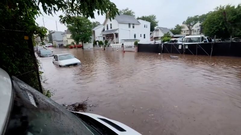
Flood Warnings for Eastern NY as Storm Hits New England
Life-Threatening Conditions Spread Across Northeast
Goldlaner.com – Flood warnings issued for eastern New York and parts of New England as a powerful storm system brings dangerous conditions to the region. Meteorologists are tracking the weather event closely, with the threat zone expanding toward Massachusetts, Vermont, and Connecticut. Residents in affected areas should prepare for potential disruptions as rainfall continues to accumulate.
Extended heavy precipitation has saturated eastern New York, particularly around the Albany metropolitan area. The Hudson Valley has seen between two and six inches of rain in various locations, triggering widespread flash flooding. The slow-moving storm has allowed water to pool rapidly in low-lying areas and along major roadways, creating hazardous driving conditions.
Video footage from CNN affiliate WRGB captured dramatic scenes in Guilderland, New York, where vehicles became trapped in rising waters. Emergency responders helped stranded motorists, including one man who carried a child from a submerged car while assisting another person through waist-deep water. These images highlight the immediate risks facing local communities.
What to Expect: Forecast and Regional Impact
Over eleven million people live in areas under flood watch conditions on Wednesday, stretching from eastern New York through western New England. The highest risk zone covers eastern New York, Massachusetts, Vermont, and Connecticut, where meteorologists have assigned a Level 3 of 4 risk for flooding rain. This elevated rating signals that significant, potentially life-threatening flooding remains likely.
Heavy rain is expected to move into eastern Massachusetts, including the Boston area, later on Wednesday. Forecast models show rainfall totals of two to four inches across much of southwest New England. However, the National Weather Service warns that mountainous areas like the Berkshires and Worcester Hills could receive up to five to seven inches. Higher elevations will help pull additional moisture from passing air masses, boosting precipitation rates.
The storm continues its northeastward movement after soaking through New Jersey and Pennsylvania. Northern New Jersey communities logged between two and five inches of rain. New York City avoided the worst flooding impacts overnight, with its flood watch ending by Wednesday morning. While scattered showers may continue through Wednesday, the major flooding threat has decreased in the city.
Rescue Efforts and Travel Disruptions
Emergency teams have conducted numerous rescue operations across the region. The Paterson, New Jersey, fire department saved at least twenty people from floodwaters, including one individual who remained stuck in a wheelchair. Transportation networks have also faced significant challenges, with two lanes of US 1/9 closed in both directions near the Pulaski Skyway in Hudson County, New Jersey, shortly after midnight Wednesday.
Staten Island saw multiple vehicle strandings late Tuesday night as floodwaters overwhelmed local roads. Similar conditions affected parts of New Jersey and Pennsylvania throughout Monday and Tuesday. In Coalport, central Pennsylvania, the Rescue Hose & Ladder Co. fire department rescued three people and two dogs from a flooded home. Meanwhile, eastern Pennsylvania reported five individuals, including a child, needing rescue when floodwater filled their vehicle on a low-lying road in Reading.
Airport operations across the region have struggled with the heavy rainfall. Hundreds of flights were canceled at New York City area airports on Tuesday. By early Wednesday, approximately two hundred flights had been canceled with many more delayed. Travelers are advised to check with their airlines before heading to the airport.
Frequently Asked Questions
Which areas are under flood warnings? Flood warnings have been issued for eastern New York, parts of Massachusetts, Vermont, and Connecticut. The highest risk zone includes areas where rainfall totals have reached two to six inches.
When will conditions improve? The storm system is moving northeastward, with the most severe conditions expected to ease by Thursday morning. However, residual flooding may persist in low-lying areas for several days.
Are airports affected by the storm? Yes, hundreds of flights were canceled at New York City area airports on Tuesday, with approximately two hundred cancellations reported by early Wednesday. Travelers should verify flight status before departure.
What safety precautions should residents take? Residents should avoid driving through flooded roadways, move vehicles to higher ground if possible, and monitor local emergency alerts. The National Weather Service recommends staying informed about evolving conditions in your area.
