Severe thunderstorm outbreak to target the Midwest Wednesday with intense tornadoes possible
Severe Thunderstorm Outbreak Targets Midwest on Wednesday
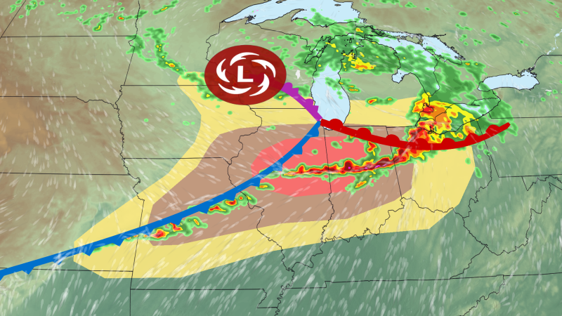
Severe thunderstorm outbreak to target the Midwest – As a powerful storm system sweeps across the central United States, the Midwest is preparing for a severe thunderstorm outbreak that could bring destructive tornadoes, heavy hail, and damaging winds on Wednesday. Meteorologists are closely tracking the event, which is shaping up to be one of the most intense in June, with the potential to disrupt communities and infrastructure. The forecast highlights the likelihood of severe weather that could escalate quickly, requiring heightened vigilance from residents.
Unusual Weather Conditions in the Region
This year’s storm system is generating an atypical surge of atmospheric energy, fueled by a convergence of warm, moist air from the Gulf of Mexico and colder, drier air from the north. These contrasting air masses are creating instability that could lead to severe thunderstorms more frequently than usual. The event is particularly notable for its strength, which surpasses typical June patterns, increasing the chances of tornado development in areas that are not traditionally high-risk.
With the system intensifying over the next 24 hours, forecasters warn that the region’s weather could turn volatile. The storm’s unusual configuration—marked by strong temperature gradients and high moisture levels—sets the stage for a more significant threat than what has been seen in recent years. This combination of factors is likely to produce the kind of conditions that favor tornado formation, even in regions where such activity is rare during this season.
Wednesday’s Forecast and Regional Impact
Severe weather is expected to peak in the afternoon as the storm system reaches its full strength. Earlier storms in Iowa and northern Illinois have already set the tone for the day, with wind gusts reaching near-hurricane levels in Albion, Iowa. While these initial storms have subsided, new developments are anticipated to follow, particularly in Missouri, Indiana, and parts of southern Illinois.
The National Weather Service has raised alerts for severe thunderstorms, noting a Level 4 risk in certain areas. This classification indicates a high probability of tornadoes, large hail, and damaging winds, all of which could compound the effects of the ongoing weather pattern. The broader region faces a Level 3 risk, still warranting caution due to the potential for localized devastation and prolonged storm activity.
Supercell Thunderstorms and Tornado Threats
Supercell thunderstorms are anticipated to be a key driver of Wednesday’s severe weather, with their rotating updrafts creating favorable conditions for tornado development. While these storms are more commonly associated with tornado production, the risk extends to other storm systems as well, given the dynamic atmospheric environment. The Midwest’s flat terrain and favorable wind patterns make it especially vulnerable to these extreme weather events.
Forecasters warn that tornadoes could reach EF3 or higher, with wind speeds exceeding 135 mph. Such powerful twisters are capable of toppling trees, destroying homes, and causing widespread power outages. Although these worst-case scenarios are not guaranteed, the storm system’s strength has elevated the probability of tornado formation above average for this time of year. The extended life cycle of the storms adds to the challenge, as they may linger for hours and cover large distances.
As the storm system evolves, the risk zones are expected to shift. By late Wednesday, the cold front will interact with the existing weather pattern, potentially expanding the area of impact. This could lead to a broader swath of severe weather, with tornadoes and heavy rainfall affecting regions that are not typically prone to such events. Residents are advised to stay updated on the latest forecasts and take necessary precautions.
Historical Context and Climate Factors
Historically, June has been a relatively calm month for tornado activity in the central United States. However, this year’s severe thunderstorm outbreak is part of a larger trend influenced by climate change. Warmer temperatures and increased atmospheric moisture have made extreme weather events more frequent and intense, even during traditionally quiet seasons. The current storm system is a direct result of these long-term climatic shifts, which have altered traditional weather patterns.
The Midwest’s vulnerability to severe weather is compounded by its geographical location and the frequency of such systems. While the region has experienced a multi-day storm activity last week, the upcoming event is expected to be more severe. This escalation underscores the importance of preparedness, as the combination of climate factors and a strong storm system could lead to significant disruptions and long-term consequences for the area.
