Major flood threat for Texas and Gulf states this week as tropical moisture supercharges storms
Severe Flooding Alert for Texas and Gulf Coast Regions as Tropical Moisture Intensifies Storm Activity
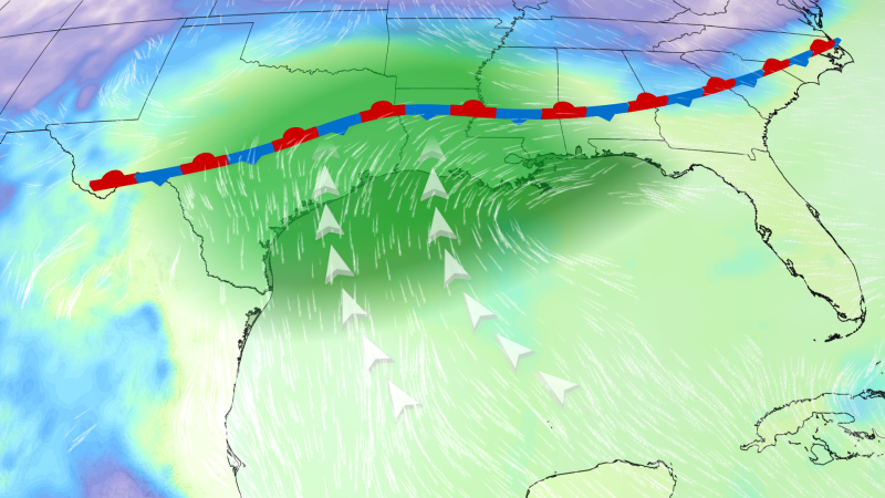
Major flood threat for Texas and Gulf – This week, Texas and parts of the Gulf Coast are bracing for severe flooding due to a prolonged heavy rainfall event amplified by an unusual influx of tropical moisture. The National Weather Service has issued flood watches for over 20 million residents spanning from central Texas to central Mississippi, signaling the potential for widespread water-related emergencies. Key cities such as Brownsville, San Antonio, and Houston in Texas; Lake Charles, Louisiana; and Jackson, Mississippi, are particularly vulnerable to flash floods that could pose life-threatening risks.
Moisture from the remnants of Tropical Storm Cristina, which formed in the Eastern Pacific last week, is playing a critical role in fueling the current weather pattern. According to the National Hurricane Center, there’s a low probability this system could evolve into the first tropical depression or storm of the Atlantic season if it moves offshore into the northwest Gulf by late Tuesday or Wednesday. Even if it remains over land, the interaction of its moisture with a stalled weather front will lead to intense rainfall, with hourly rates potentially reaching 3 to 5 inches. This persistent downpour could trigger widespread flooding, especially in areas already saturated from earlier rain events.
Emergency Response Efforts Underway Across Multiple Counties
Residents in central and southern Texas are already experiencing the effects of the flooding, with water rescues reported in several locations. Bandera County Emergency Management Coordinator Judy Lefevers shared with CNN that responders were actively searching for the driver of a vehicle swept away by floodwaters early Monday. She also noted that multiple low water crossings in the county had become impassable, requiring urgent assistance. Similar incidents occurred in Travis County, where emergency officials reported that about 80 low water crossings were flooded as of Monday morning. One individual was rescued after becoming stranded at a crossing, according to county Director of Emergency Management Andy Brown.
“We’ve had to deploy resources quickly to address stranded vehicles and ensure safe passage through affected areas,” said Andy Brown, reflecting the strain on local response teams.
Neighboring Williamson County also saw assistance efforts as drivers were trapped at two separate low water crossings. County spokesperson Connie Odom emphasized the importance of vigilance, stating that the situation remains dynamic and requires continuous monitoring. In Bexar County, multiple water rescues were conducted Monday morning, with the Fire Marshal and Emergency Management Coordinator, Chris Lopez, confirming that several vehicles were stranded on Interstate 35 in Waco, Texas, during Sunday night’s flooding.
“This level of flooding in Waco is unlike anything I’ve seen before,” said Texas Game Warden Capt. Matthew Kiel, describing the severity of the situation in rural McLennan County, where most low water crossings had turned into hazardous zones.
The Texas Department of Transportation reported that vehicles were trapped in floodwaters on parts of Interstate 35, highlighting the challenges faced by commuters and emergency crews. Kiel added that the flooding extended to Milam, Williamson, and Burleson counties, underscoring the regional nature of the crisis. These incidents have already prompted evacuations and heightened awareness among residents, with local authorities urging caution on roads and near waterways.
Projected Flooding Zones and Risk Levels
The Weather Prediction Center has classified the flash flooding risk as Level 3 out of 4 for areas in Texas, Louisiana, and Mississippi from Monday to Thursday. This level of alert, which indicates a high likelihood of significant flooding, has not been issued for consecutive days across the U.S. since July 2025. The National Water Center estimates that rainfall totals could reach 5 to 10 inches in affected regions, with some localized areas potentially receiving even higher amounts.
Regional impact areas are expected to shift over the next few days, with specific zones of concern outlined as follows: •
Through Monday night: South Texas, extending up the coast to Houston, will see the highest flood threat, along with western and central Louisiana and west-central Mississippi.
•
Tuesday to Tuesday night: Coastal Texas and southwest Louisiana are projected to face the most critical conditions, with localized flooding possible as far east as central and southern Alabama and west-central Georgia.
•
Wednesday to Wednesday night: The upper Texas coast, including Houston and Galveston, and southwest Louisiana will experience the most dangerous flooding, particularly where earlier rains have already saturated the ground.
•
Thursday to Thursday night: Extreme southeast Texas, much of western and northern Louisiana, and west-central Mississippi will have the most significant flood risk, with potential for flash flooding in isolated areas.
The extended rainfall pattern is creating a domino effect, with rivers and creeks swelling beyond their banks and urban drainage systems overwhelmed. Emergency management teams are preparing for additional challenges, including possible evacuations and road closures. In some regions, the risk of mudslides and landslides is also rising, as saturated soil becomes more unstable.
Historical Context and Climate Implications
While this event is not yet the first tropical storm of the Atlantic season, it highlights the growing influence of tropical moisture on weather systems in the central U.S. The National Water Center’s warning underscores that the current rainfall totals are unusually high for June, raising questions about climate patterns and the increasing frequency of extreme weather events. Scientists note that rising global temperatures may be contributing to more intense and prolonged rainfall episodes, which can lead to catastrophic flooding in vulnerable regions.
Historical data shows that the Level 3 threat level has only been issued for multiple consecutive days in the U.S. since July 2025, making this week’s situation particularly notable. The combination of tropical moisture and a stalled weather front has created a unique set of conditions, with some areas receiving rainfall far exceeding normal seasonal averages. This has forced emergency planners to adopt more aggressive response strategies, including pre-positioning equipment and coordinating with neighboring states to manage the scale of the crisis.
Residents are being advised to monitor local weather updates and take precautions such as avoiding low-lying areas and keeping emergency supplies ready. School districts and businesses in affected regions have also implemented contingency plans, with some schools closing early and companies adjusting work schedules to minimize exposure to flood risks. The situation is expected to peak by midweek, with the most severe impacts likely to occur in the Houston and Galveston areas, where the convergence of tropical moisture and heavy rains will create the most hazardous conditions.
As the week progresses, the National Weather Service will continue to update flood warnings based on real-time data. The resilience of communities in Texas and the Gulf Coast will be tested, with both individuals and infrastructure facing the consequences of this extreme weather. The event serves as a stark reminder of the power of climate-driven weather patterns and the need for proactive measures to mitigate their effects.
For further details on the current flood threat, visit this link. The hashtag #flooding and #txwx are being used to track updates and share experiences on social media platforms like Twitter, where the article was originally posted. The ongoing situation is likely to draw attention to the broader implications of climate change, as regions that were once considered less prone to severe flooding now face increasingly frequent and intense weather events.
