Deadly 7.8 magnitude earthquake hits southern Philippines
Deadly 7.8 Magnitude Earthquake Hits Southern Philippines
Deadly 7 8 magnitude earthquake hits – A powerful earthquake measuring 7.8 on the Richter scale hit the southern Philippines on Monday, according to the United States Geological Survey (USGS). The tremor caused widespread panic, with reports of buildings collapsing and multiple fatalities in the affected regions. The event struck at approximately 07:37 a.m. local time, with its epicenter located about 35 kilometers (21.7 miles) beneath the earth’s surface, as per USGS data. The disaster unfolded as public schools across the area began the new academic year, leaving students and staff in a state of alarm.
Tsunami Warnings and Regional Impact
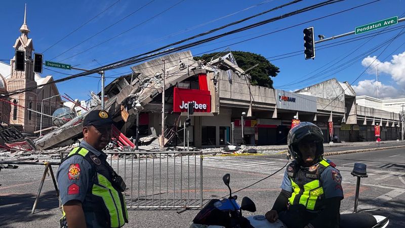
The Philippine Institute of Volcanology and Seismology (Phivolcs) confirmed the quake hit near the shores of General Santos City in Sarangani province, marking the southernmost point of Mindanao island. Local authorities in General Santos City, a city home to roughly 720,000 residents, shared images showing convenience stores and structures in disarray after the tremor. The destruction was particularly visible in areas where the ground shook violently, upending everyday life.
President Ferdinand Marcos Jr. issued a statement urging immediate action from government agencies to evacuate residents and initiate rescue operations. “To our kababayans [countrymen] in the affected provinces, please heed the tsunami warning. Move to higher ground now. Do not wait. Your life is more important than anything left behind,” he emphasized, highlighting the urgency of the situation. The president’s call to action was echoed by officials in nearby provinces, as the quake’s aftermath prompted heightened awareness of potential secondary threats.
Tsunami alerts were raised by the Philippines, Indonesia, and Japan, though the Pacific Tsunami Warning Center noted the danger had largely subsided five hours after the initial quake. Despite this, the center advised continued vigilance, as sea levels might still fluctuate. The three countries, situated along the Ring of Fire—a seismic zone known for frequent tremors and volcanic activity—remain particularly vulnerable to such events.
Impact on Educational Institutions
Social media videos captured harrowing scenes of elementary schoolchildren crouching in fear outdoors as the ground swayed violently in Davao Occidental. In Davao Del Sur, footage showed a high school’s roof collapsing while students gathered on the sports field. Although no injuries were reported in these incidents, the panic among students underscored the earthquake’s disruptive force. The timing of the quake, coinciding with the start of the academic year, added to the sense of unpredictability and fear.
Photos from the local information office in General Santos City depicted collapsed buildings and shattered storefronts, providing a visual account of the destruction. The quake’s intensity was described as “the strongest we’ve experienced” by Benjie Ancheta, the police chief of Alabel town in Sarangani province. Ancheta, speaking to Reuters, noted that the police building sustained cracks shortly after the tremor, though no immediate casualties were confirmed. He also mentioned that some individuals fainted during the shaking, illustrating the quake’s physical and psychological toll.
“The ground shook so hard it felt like the world was ending,” Ancheta said, reflecting on the moment. This sentiment was shared by many in the region, as the earthquake disrupted routines and exposed the fragility of infrastructure. Response teams are currently on the ground assessing damage and verifying casualty reports, with initial figures indicating several deaths and dozens of people affected.
Global and Local Responses
Following the quake, authorities in the Philippines intensified efforts to monitor the situation, with the Office of Civil Defense providing updates on the number of confirmed fatalities. The agency also urged the public to remain cautious, as the disaster could trigger further complications. Meanwhile, the Pacific Tsunami Warning Center assured that the threat had diminished significantly, but it still recommended staying alert and following local advisories.
Amid the chaos, the national government took swift measures to coordinate relief efforts. Marcos Jr. directed agencies to prioritize evacuation and rescue operations, ensuring that resources were quickly mobilized to support affected communities. The president’s statement emphasized the importance of immediate action, as the region’s vulnerability to tsunamis remains a critical concern. In the wake of the earthquake, local leaders and emergency personnel worked tirelessly to stabilize the situation and provide aid to those in need.
The Ring of Fire, an arc of fault lines encircling the Pacific Basin, continues to pose a significant risk to the southern Philippines and neighboring countries. This geological phenomenon, responsible for frequent earthquakes and volcanic eruptions, underscores the region’s ongoing exposure to natural disasters. The recent quake serves as a reminder of the importance of preparedness and resilience in communities situated along these active fault lines.
In Hawaii, the National Weather Service reported no tsunami threat, providing some reassurance to residents in the Pacific Northwest. However, the warning system’s activation across multiple countries highlights the interconnectedness of seismic events and the necessity for global cooperation in disaster response. As the situation evolves, further updates are expected to detail the full extent of damage and the number of people impacted by the quake.
