Severe storms with intense tornadoes possible in Central US through Monday
Severe Storms and Tornado Threats Loom Over Central US Through Monday
Severe storms with intense tornadoes possible – May has begun with unusually calm weather, but the Central United States is now on high alert for a significant weather event. A volatile stretch of severe thunderstorms is expected to unfold across the Plains and Midwest through Tuesday, bringing the risk of intense tornadoes—EF3 or stronger—alongside destructive hail, damaging winds, and heavy rain. This surge marks a dramatic departure from the muted weather pattern observed earlier in the month, as a persistent jet stream configuration has kept widespread severe storms at bay until now.
Storm Development and Tornado Timing
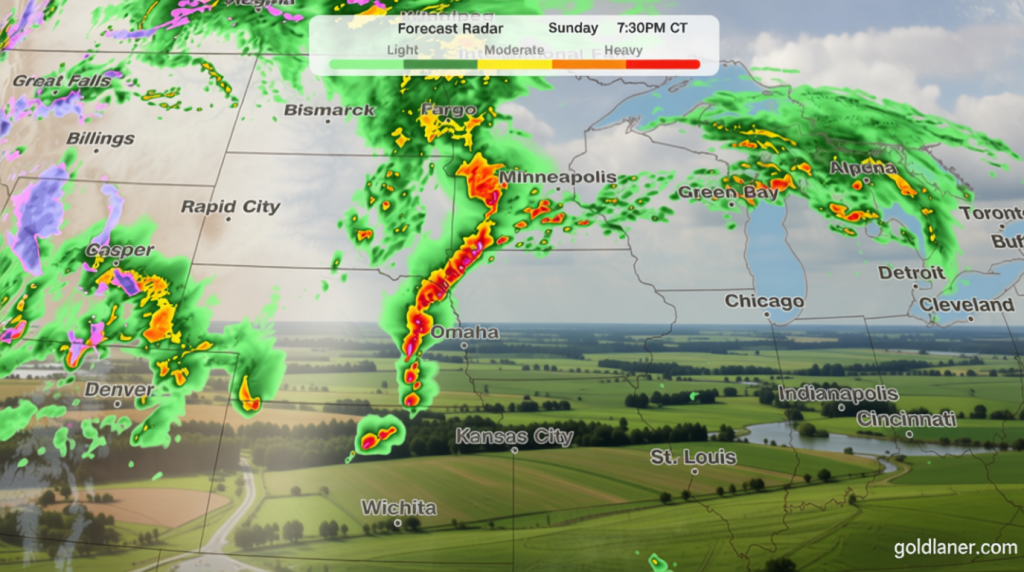
Forecasters are closely monitoring the progression of this system, which is set to intensify over the weekend. On Sunday, the first wave of storms will rapidly develop during the mid to late afternoon in Nebraska and southeastern South Dakota. These thunderstorms are anticipated to generate very large hail, with the highest tornado threat occurring in the evening hours. The region under focus includes eastern Nebraska, southeast South Dakota, and western Iowa, where cities like Omaha, Lincoln, and Sioux City could face the most danger between 4 p.m. and 10 p.m. CT.
By Monday, the situation is expected to escalate as the jet stream’s strongest surge interacts with abundant moisture in the Plains. This interaction will fuel widespread severe thunderstorms, with supercells likely forming in the afternoon. These supercells could spawn tornadoes rated EF2 or stronger, alongside large hail. The primary tornado threat will span central and eastern Kansas, southeastern Nebraska, and northwestern Missouri, where conditions are primed for significant damage. However, as the day progresses, the focus will shift toward damaging winds, which are projected to become the dominant concern by late evening. The exact timing of storms and cloud cover in the morning remains a key variable, as it could influence afternoon and evening conditions. Areas where storms linger overnight may experience reduced energy, potentially lowering the likelihood of tornadoes.
“The combination of dry fuels, sustained winds of 25 to 30 mph, and relative humidity under 10% creates a dangerous environment for fires to spread rapidly,” said the National Weather Service.
The same system responsible for the tornado threat will also contribute to extremely dry and windy conditions in the Southern High Plains, increasing the risk of wildfires. This dual threat highlights the complex interplay between storm systems and regional weather patterns.
Weather Pattern Shifts and Regional Impacts
As the storm system moves eastward, the threat of tornadoes will lessen on Tuesday, with thunderstorms expected to persist from northern Texas to Michigan. While the morning will see scattered storms, the risk of strong to severe weather will peak in the afternoon. The cold front becoming dominant will shift the focus from tornadoes to damaging winds and hail, as the system’s energy transitions. This change will reduce the likelihood of EF3 or stronger tornadoes but maintain a significant risk for smaller ones, such as EF2, in the central and eastern regions.
The fire threat in the Southwest remains a critical concern, particularly in areas like Arizona and southwest Kansas. A level 3 of 3, extremely critical fire threat exists Sunday and Monday, with southwestern Kansas to the Texas Panhandle and northeastern New Mexico under the highest risk. A level 2 threat covers a broader area, including much of New Mexico, which could see dry conditions persist due to the same weather system. The National Weather Service warns that any ignitions in these zones could lead to life-threatening spread, emphasizing the need for vigilance in both storm and fire-prone regions.
Historical Context and Forecast Significance
May is renowned for its severe weather outbreaks, often setting the stage for some of the most impactful spring storms. This year’s forecast could match historical trends, with the potential for multiple tornadoes to develop across the Central Plains and Midwest. The jet stream’s earlier suppression of storms has led to a delayed but more intense pattern, which meteorologists believe may result in a notable event. The transition from quiet to active weather underscores the unpredictable nature of atmospheric systems and their ability to shift rapidly.
Weather models suggest that the system’s interaction with warm, moist air in the Plains will create favorable conditions for supercell formation. These cells are known for their ability to generate long-track tornadoes, which can cause widespread damage. The timing of the storm is also crucial, as the region is entering a phase where late spring temperatures and humidity levels are at their peak, amplifying the potential for severe weather. Farmers, residents, and emergency planners are being advised to prepare for the possibility of significant impacts, including power outages, infrastructure damage, and travel disruptions.
Extended Outlook and Preparedness Measures
Looking beyond the immediate forecast, the system’s influence may extend into the following week. While the primary tornado threat is expected to taper off by Tuesday, the risk of heavy rain and strong winds could linger, potentially leading to flash flooding and downed trees. The Southwest’s fire danger, however, is projected to remain elevated, with dry conditions persisting due to the system’s high-pressure ridge. This could create a scenario where both tornadoes and wildfires coexist, challenging local authorities to manage multiple threats simultaneously.
Residents in the Central US are urged to stay informed about weather updates and take necessary precautions. Tornado warnings will be issued based on radar data and storm tracking, with areas like eastern Nebraska and western Iowa being prime locations for alerts. For the fire threat, evacuation plans and resource allocation will be critical, especially in regions with dense vegetation and high fuel loads. The National Weather Service continues to monitor both scenarios, providing real-time updates to ensure communities are prepared for the full range of possible outcomes.
Experts note that the severity of this storm system is influenced by several factors, including soil moisture levels, atmospheric instability, and wind shear. The dry conditions in the Southern High Plains, combined with the moisture from the Plains, create a stark contrast that can lead to extreme weather events. This dynamic is particularly notable as the system moves, altering its impact from tornadoes to wind and fire threats. The Central US’s history with severe weather means that this forecast is a major event, with the potential to rank among the most active in recent years.
As the weekend approaches, meteorologists are preparing for the possibility of multiple tornadoes, with the EF3 rating being a focal point. The timing of these storms, peaking in the evening hours, requires specific attention, especially for those in high-risk zones. Meanwhile, the Southwest faces a critical fire threat, with conditions in Arizona and New Mexico posing significant risks. This dual challenge highlights the importance of monitoring both weather patterns and fire behavior, as they can have cascading effects on communities and ecosystems.
Conclusion and Regional Resilience
While the Central US braces for a weekend of intense thunderstorms and tornadoes, the Southwest faces its own set of challenges. The interplay between these two regions demonstrates the interconnectedness of weather systems and their ability to affect diverse areas. As the forecast unfolds, the focus will shift from one threat to another, testing the resilience of affected communities. The upcoming days will be a critical test of preparedness, with the potential for both destructive tornadoes and hazardous wildfires to impact the region.
Residents and officials alike are being reminded to stay alert and take action. Whether it’s securing property against falling trees or ensuring firebreaks are in place, the emphasis is on proactive measures. The National Weather Service and local authorities will play a key role in communicating updates, helping people navigate the unpredictable weather. This storm system serves as a reminder of the power of nature and the need for continuous vigilance in the face of extreme weather events.
