
Hurricane Isaias Puts Northern Gulf Coast on High Alert
Goldlaner.com – Communities along the northern Gulf Coast are preparing for a potentially dangerous hurricane strike after Isaias strengthened quickly into the first Atlantic hurricane of the season. The storm threatens coastal areas with surge flooding, destructive wind, heavy rain and the possibility of tornadoes as it approaches landfall late Friday or early Saturday.
Aircraft flying into the storm confirmed Wednesday night that Isaias had sustained winds of 75 mph, placing it at Category 1 hurricane strength. At that time, the hurricane was roughly 450 miles south-southwest of the Mississippi River’s mouth.
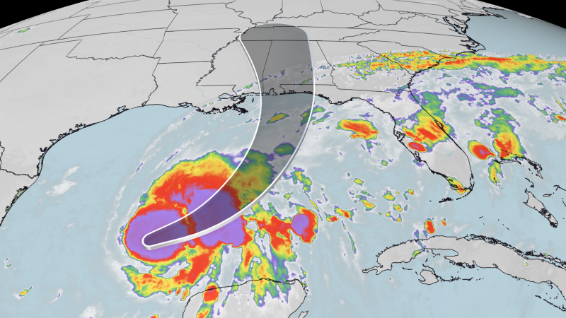
Forecast guidance calls for Isaias to travel east-northeast for about another day before making a sharp turn toward the northern Gulf Coast. Additional strengthening remains possible over the Gulf, with the system potentially reaching Category 2 intensity and winds near 110 mph by early Friday. Some weakening is anticipated before landfall, but forecasters still expect it to arrive as a dangerous hurricane.
Landfall zone remains uncertain
The projected landfall area has narrowed, stretching from the Mississippi coast eastward to the western Florida Panhandle. Even within that zone, the precise crossing point and the hurricane’s strength at arrival remain uncertain. Residents should not focus solely on the forecast line, since hazardous weather can extend far from the storm’s center.
A hurricane warning covers the coast from Ocean Springs, Mississippi, to the Bay-Gulf county line in Florida, including Alabama’s shoreline. Within the warning area, hurricane-force winds of at least 74 mph are possible within 36 hours.
A storm surge warning is also in place from the Mississippi River mouth to Florida’s Steinhatchee River. Strong onshore winds can force Gulf water inland, causing coastal flooding well before the hurricane’s core comes ashore and potentially making roads impassable in vulnerable areas.
Why the eastern side may see the harshest conditions
Isaias is expected to become more uneven, or lopsided, as it nears the coast. That structure means the most serious effects — including the strongest winds, heaviest downpours, highest surge and greater tornado risk — are likely to occur along and east of its center track.
Coastal rain, gusty conditions and flooding concerns may begin increasing Friday morning. The weather is expected to deteriorate through the afternoon and evening, with the most intense impacts arriving around landfall and continuing into Saturday morning.
From far southeastern Louisiana through the Florida Panhandle, rainfall totals of 3 to 6 inches are forecast, while isolated locations could receive as much as 10 inches. Other parts of the Southeast, reaching into the Carolinas and Tennessee Valley, could see up to 5 inches through Saturday.
Because Isaias is forecast to move at a relatively quick pace, widespread prolonged flooding may be limited. Still, fast-moving tropical systems can produce dangerous flash flooding where intense rain repeatedly falls over the same small area. Southern Alabama and the western Florida Panhandle face the greatest risk from the storm’s heaviest rain bands.
States activate emergency plans
Florida Gov. Ron DeSantis declared an emergency Tuesday covering 25 counties and urged residents to prepare household disaster plans and assemble hurricane supplies. Emergency teams have positioned generators, fuel, food, water and flood barriers around Tallahassee and Santa Rosa in anticipation of storm-related needs.
Mandatory evacuation orders are already affecting parts of the Florida Panhandle. Okaloosa County ordered people in coastal areas to leave beginning at noon Thursday, while visitors from outside the area were urged to depart by Wednesday evening. Gulf County also ordered evacuations for recreational vehicles at three parks and campgrounds because of possible flooding.
In Alabama, Gov. Kay Ivey declared an emergency Wednesday for 40 counties. Dauphin Island announced a voluntary evacuation beginning Thursday evening for an estimated 350 to 400 homes, primarily in low beach areas at the island’s western end. Many of those properties are vacation homes and rental units.
“Encouraged to begin preparing and relocate if needed,” Baldwin County’s emergency management agency said of people living in coastal and low-lying locations.
Residents in evacuation zones should leave early enough to avoid hazardous travel conditions. Those outside official zones should review local alerts, secure outdoor items, prepare for possible power outages and avoid driving through flooded roads. A hurricane warning means preparations should be completed quickly rather than delayed until severe weather begins.
Offshore operations take precautions
Energy companies operating in the Gulf are also moving to protect workers and facilities. Shell is sending nonessential personnel away from six offshore platforms, while BP is removing nonessential workers and securing its own offshore operations.
Rapid strengthening has become a major concern with Gulf tropical systems. A storm is considered to undergo rapid intensification when its sustained wind speed rises by at least 35 mph within 24 hours or less. Warmer oceans and a warming climate driven by fossil fuel pollution are contributing to an environment in which more hurricanes are capable of intensifying quickly.
For Gulf Coast residents, the practical message is that Isaias should be treated as a broad regional threat, not simply a point on a forecast map. Conditions can change quickly, and the most damaging weather may occur well away from where the hurricane’s center eventually crosses the coastline.
Related Reading
Frequently Asked Questions
What is Isaias rapidly intensifies into season s first?
Isaias rapidly intensifies into season s first is the main topic of this guide. The article explains the context, practical details, and next steps readers should understand.
Why does Isaias rapidly intensifies into season s first matter?
Isaias rapidly intensifies into season s first matters because readers are looking for a useful answer, not just a short summary. Good content should match search intent and help them decide what to do next.