
Unusually strong summer storm puts New York City at the center of a Northeast flash flood threat
Unprecedented Summer Deluge Brings Flash Flood Danger to Northeast Metropolis
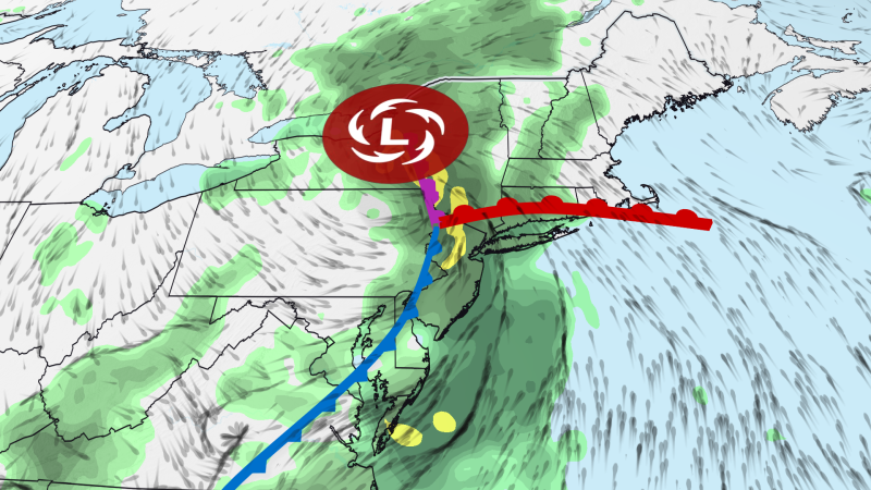
Goldlaner.com – Residents across the northeastern United States face mounting concerns as an exceptionally powerful storm system threatens to unleash life-threatening flooding conditions through Tuesday evening. This remarkable weather event has the potential to deliver more than a full month’s precipitation in certain sections of the region within just a few days. Authorities have issued flood watches for over 35 million individuals spanning from Baltimore and Philadelphia northward through the New York metropolitan region and into southwestern New England.
Rainfall Projections and Urban Vulnerability
Widespread precipitation amounts between three and five inches are anticipated across the affected zone, with certain pockets potentially receiving as much as seven inches. These heaviest totals are expected from northeastern New Jersey through the Lower Hudson Valley and into southwestern Connecticut. Notably, the upper portion of this range exceeds New York City’s typical July precipitation average of 4.60 inches.
The primary danger stems from rainfall falling at torrential speeds of one to three inches per hour over densely populated urban centers. Such intense downpours can rapidly overwhelm existing stormwater drainage systems. While New York City’s infrastructure is designed to manage rates up to 1.75 inches per hour, this capacity is being exceeded with increasing frequency. Climate scientists attribute this trend to planet-warming pollution that elevates temperatures, enabling warmer air to retain greater moisture content. When weather patterns extract this accumulated humidity, they produce heavy and frequently localized downpours.
Monday’s Warning Signs
Monday provided an early indication of what residents might expect. Isolated thunderstorms ignited in northern New Jersey ahead of the main system. Radar data indicates that a sluggish thunderstorm deposited more than three inches of rain near Glen Rock and Ridgewood, creating flooding across portions of Bergen and Passaic counties. Dramatic footage captured in Glen Rock revealed a BMW almost completely submerged in water. Two occupants managed to escape before emergency responders arrived, though the depth initially prevented a tow truck from reaching the vehicle. Multiple water rescue operations occurred throughout Glen Rock, Hawthorne, and Fair Lawn.
Unusual Storm Characteristics
The storm’s intensity on Wednesday, when it decelerates and strengthens, will rival systems typically observed during colder seasons rather than late summer. Such powerful configurations are uncommon in July because the jet stream usually provides less energy for intensification. Simultaneously, this system is drawing upon enhanced moisture corridors from both the Atlantic Ocean and the Gulf of Mexico. Water vapor concentrations within this air mass will surpass typical midsummer humidity levels significantly.
These contrasting atmospheric conditions will generate several cycles of heavy rain and thunderstorms throughout the northeastern corridor. The New York tri-state region, extending from northern New Jersey to western Connecticut, faces the greatest flooding risk during Tuesday and Tuesday night, though localized threats extend across most of the broader Northeast.
Travel Disruptions and Historical Context
Urban neighborhoods and areas with inadequate drainage will experience the most severe flooding impacts. Some locations could witness consequences reaching serious levels, similar to events documented multiple times across the nation this month, including a significant incident in New York City on July 18. Locations where rain bands decelerate or remain stationary for extended periods will endure the worst flooding.
Transportation disruptions are anticipated at regional airports and roadways. FlightAware reports hundreds of Tuesday cancellations at major airports throughout the area. Flash flooding remains among the most lethal weather phenomena, particularly within urban environments. Nearly five years ago, Hurricane Ida claimed dozens of lives in the Northeast when it deposited seven to ten inches of rain across a comparable corridor to this week’s threat.
Severe thunderstorms also pose risks on Tuesday from Philadelphia and Washington, DC, extending toward the Carolinas. While wind damage represents the primary concern for strengthening storms, isolated tornadoes remain possible. The broadest flash flood threat will gradually shift northward on Wednesday into southern and central New England, encompassing Boston and Hartford, while New York City continues to face danger. Persistent downpours are expected across this entire region as Wednesday progresses.
Related Reading
Frequently Asked Questions
What is Unusually strong summer storm puts New York?
Unusually strong summer storm puts New York is the main topic of this guide. The article explains the context, practical details, and next steps readers should understand.
Why does Unusually strong summer storm puts New York matter?
Unusually strong summer storm puts New York matters because readers are looking for a useful answer, not just a short summary. Good content should match search intent and help them decide what to do next.
