
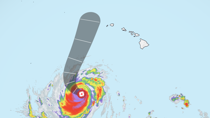
Hurricane Lowell Makes Final Turn Toward Hawaii
Goldlaner.com – For days, a stubborn upper-level ridge locked a major hurricane into a westward corridor, keeping it safely south of the Hawaiian chain. That invisible ceiling collapsed over the weekend when a cold-air trough plunged south from the North Pacific and merged with a nearby low. Freed from the ridge’s grip, Hurricane Lowell makes final turn toward the western islands, swinging northward in a maneuver that places the storm on a direct collision course with Kauai and Niihau. It is the third system in barely three weeks to aim squarely at the archipelago — a pattern meteorologists attribute to El Niño’s amplification of Pacific-basin convection.
Forecast Track and Current Intensity
Per the latest National Hurricane Center advisory, Lowell is a Category 3 hurricane sustaining 120 mph winds and advancing northward at roughly 9 mph. The storm has oscillated between categories during its basin passage, a normal cycling behavior for a major hurricane. Forecasters project weakening to near Category 2 intensity by the time of closest approach.
The projected center track places the storm approximately 100 miles west of Niihau and 150 miles west of Kauai from late Monday night through Tuesday morning local time. That offshore positioning keeps the most violent winds away from populated areas, yet the islands will still endure dangerous surf, torrential rainfall, and elevated mudslide risk. Tropical-storm-force winds exceeding 39 mph are expected to reach the western islands late Monday into Tuesday. On elevated terrain — ridgelines and steep slopes — gusts may briefly reach hurricane force as the islands’ topography accelerates airflow.
Surf, Rain, and Flooding Threats
Long-period swells generated by the hurricane are already producing hazardous conditions statewide, with a high surf warning in effect through early Tuesday for south-facing shores of Oahu, Maui County, and the Big Island. The National Weather Service in Honolulu projects that 7- to 10-foot surf will build rapidly Monday afternoon and evening, escalating to 12–20 feet along Oahu’s south coast and 12–16 feet across Maui County and the Big Island. Waves of that magnitude can overrun beaches, inundate low-lying coastal roads, and threaten harbor infrastructure. Powerful rip currents and large breaking waves compound the danger at beach access points and harbor entrances.
Heavy rainfall will blanket the entire state. Kauai and Niihau face 6 to 10 inches of rain, with isolated totals potentially exceeding 14 inches. The Big Island is forecast to receive 4 to 8 inches, with isolated accumulations up to one foot. Oahu, Molokai, Lanai, and Maui are expected to see 2 to 4 inches on average, though mountainous zones on those islands could accumulate as much as 8 inches. The National Hurricane Center has issued explicit warnings for significant flash flooding and mudslides, particularly in steep terrain. As of Sunday afternoon, multiple roads on Oahu were already flooded, disrupting traffic, per the Hawaii Department of Transportation.
Statewide Emergency Mobilization
Hawaii Governor Josh Green declared a state of emergency for the entire state, a designation that unlocks federal resources and authorizes activation of Hawaii National Guard units. Six high-water vehicles are being staged on Kauai to handle anticipated road flooding. Kauai County announced the closure of all parks and campgrounds and the establishment of five designated refuge areas beginning Sunday.
“Closing our parks and opening refuge areas is not a decision we make lightly, but it is the right call with a storm of this strength still turning toward us,” Mayor Derek S.K. Kawakami said in a statement.
The Kauai Emergency Management Agency urged residents to remain indoors and off roads as conditions deteriorate, to fill fuel tanks, charge electronic devices, and stock sufficient water and food. In Lihue — a town of roughly 8,000 that hosts Kauai’s primary airport — supermarket shelves were visibly thinning as residents stocked up ahead of the storm’s arrival.
Frequently Asked Questions
When will Hurricane Lowell makes final turn impacts hit the western islands? Tropical-storm-force winds are expected to reach Kauai and Niihau late Monday into Tuesday morning local time. Peak surf and rainfall will coincide with that window.
Do I need to evacuate my home on Kauai or Niihau? No mandatory evacuations have been ordered. However, residents in low-lying coastal zones, flood-prone valleys, or areas with limited power backup should consider relocating to one of the five county-designated refuge areas if conditions worsen.
Will flights to or from Lihue Airport be affected? Kauai County has closed all parks and campgrounds, and the airport is expected to see schedule disruptions once tropical-storm-force winds arrive. Passengers should check directly with their carrier for real-time updates.
How much rain should I expect on the Big Island or Oahu? The Big Island faces 4 to 8 inches with isolated totals up to one foot. Oahu, Molokai, Lanai, and Maui average 2 to 4 inches, though mountainous zones could see as much as 8 inches. Flash flooding and mudslides are the primary hazards on those islands.